DG saves you time and money if you are flying UAVs for capturing high-accuracy land survey data, mapping data, or GIS data
In a 2018 Drone Market Sector Report completed by Skylogic Research, it was reported that only 7% of the UAV market are using Direct Georeferencing to register their maps to the ground surface for survey and mapping purposes. An astounding 46% of respondents indicated that they do not georeference their map products, while 36% responded that they collect ground control points, typically used in a traditional process known as aerial triangulation.
While there are various methods available for georeferencing imagery, such as PPK, RTK, and Aerial Triangulation, Direct Georeferencing provides the overall most efficient process for accurately registering imagery data to ground coordinates.
How does Direct Georeferencing work?
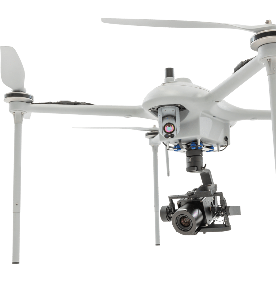
Direct Georeferencing or DG directly measures the position and orientation of an airborne mapping sensor, such as a digital camera or a laser scanner. This makes it possible to assign a geographical location on the earth to a pixel from a camera image or a digital point from a laser, without the need for ground control points or any additional measurements referencing the ground.
At its core, Direct Georeferencing uses two systems: Global Navigational Satellite Systems (GNSS) and Inertial Navigational System (INS). GNSS recording the camera coordinates “X, Y, Z”, and INS recording the camera orientation angles “w, φ, k” at the time of exposure. These parameters are merged and tagged to each photograph in the processing stage, or in the case of scanning systems, such as LiDAR, to each point.
5 WAYS THAT DG CAN SAVE YOU TIME AND MONEY
(if you are flying UAVs for the purpose of capturing land survey data, mapping or GIS data, and if accuracy is important)
Less pre-mission prep – no Ground Control Points needed
Direct Georeferencing saves a significant amount of time by not having to establish and survey extensive Ground Control Points (GCPs) for aerial triangulation (AT). Typically, in order to achieve cm level accuracy with aerial triangulation, the UAV operator requires a well-distributed network of ground control points from which the imagery can be registered. For a 20-minute mission, capturing these points can take a ½ day or longer. With DG this step is not required.
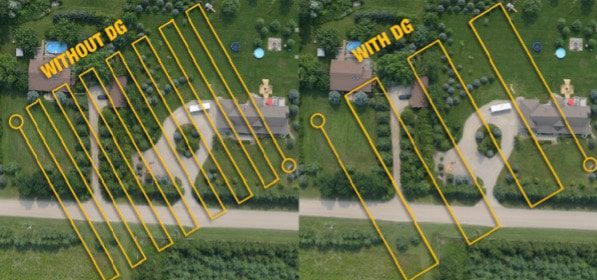
Faster or larger missions – reduction of the flight line overlap needed
With other methods of georeferencing imagery, UAVs are typically flown with an 80% sidelap and a 60% endlap. With DG this can be substantially reduced; a 40% overlap and 30% endlap would be more than sufficient.
DG allows the area flown per mission to be increased or the time required to fly a mission to be decreased by reducing the sidelap and endlap requirements that would otherwise be required for AT – thereby maximizing productivity. This becomes especially useful in disaster scenarios such as the recent hurricane devastation perpetrated by Hurricane Dorion. With DG, accurate mapping updates are flown quickly and accurately.
Faster processing – process your data in less time
Data processing can often be time-consuming, which can be a real concern for time-critical missions such as those involving rapid response or disaster relief. DG reduces processing by eliminating the need to incorporate processing for the ground control points. DG automatically uses the mathematics to process the image position and orientation and subsequently georeferences the data to ground coordinates.
In addition, data workflow and quality control is streamlined and automated. Use DG to meet tight project deadlines by eliminating extensive ground survey and reducing processing time.
Mapping anywhere – perform UAV Mapping Missions in inaccessible or Featureless Areas
The ability to conduct UAV aerial surveys within inaccessible and/or featureless areas, such as deserts or bodies of water, where established ground control is limited, renders DG virtually essential!
Achieve Better Results than RTK or PPK Alone
Many UAV mapping and survey projects continue to be completed using RTK and PPK methods alone. RTK and PPK have inherent problems that reduce their accuracy, productivity, and efficiency. Often these techniques are not able to provide the consistent accuracy that can be achieved with DG. In these cases, it may be necessary to re-fly missions in order to get the required results, which can be both costly and time consuming, especially on fixed-price contracts. Many of these problems are revealed upon a detailed analysis of their associated mathematical and scientific principles and calculations. One of the major factors for the reduced accuracy of RTK and PPK is the calculation of orientation angles of any sensor. DG actually measures the orientation angles of any imaging sensor with high accuracy and high frequency at 200Hz or more (200 times per second), thus providing a better result.
The overall savings achieved by using DG are specific to the project type, terrain configuration, type of mapping sensor, and post-processing method. From a direct labor-savings perspective, not having to establish extensive GCPs in support of AT can save many hours in labor per mission, leading to significant cost-savings per mission. From a utilization perspective, only needing to fly half the sidelap vs traditional AT (40% vs 80%) doubles the productivity of a UAV. Add in the saved time in processing and the value of DG starts to add up very quickly.
This article was written by Applanix – A Trimble Company